


Introduction
In 1991, paddy fields accounted for 63.5 percent of all farmlands in Korea, amounting to 2.11 million hectares. Compared to the gross area of paddy fields in 1919, which accounted for 34.2 percent of all farmlands at the time, the area of paddy fields has grown as much as 1.9 times larger over the course of about 70 years. In 1432, when the P’aldo Chiriji (Geographical Record of the Eight Provinces), which became the basis of the Sejong Sillok Chiriji (Geographical Appendix to the Annals of King Sejong), was published, the area of paddy fields in Korea accounted for 19 percent of all farmlands. This shows that the area of paddy fields in Korea has increased by 1.8 times over the 500 years of the Chosǒn (Joseon) Dynasty, and 1.9 times again over 70 years after the Japanese colonial period. Farming culture in modern Korean society was restructured to focus on rice farming in paddy fields over the long history of 600 years since the late fourteenth century, when rice farming began in Korea. In this aspect, it would not be an exaggeration to say that the history of the agricultural economy is a developmental history of rice farming.1
The Korean people’s obsession with rice farming was unique. Koreans who fled to Manchuria during the Japanese colonial period (1910–1945) insisted on rice farming in the area they settled, and succeeded in transforming their settlement area into rice paddies. Rice farming in Manchuria, which is located at a high latitude (42–45th parallel north) and typically cold due to the Siberian High, was evidence of the toughness of Korean migrants.2 However, this was not a unique case. In the late fourteenth and early fifteenth centuries, Koreans overcame challenges and obstacles for rice farming to take root in Korea, as rice farming began.
The natural environment in Korea was far from adequate for the development of rice farming, as this paper will further explain. However, this is significantly different from the fact that Jinan, the capital of Shandong Province, China, remained an area with dry fields, unable to overcome the long dry season that lasted until June, although Jinan (36° 40′N) is located at a similar latitude to Daegu (Taegu) (35° 52′N), the capital of Kyǒngsang Province (Gyeongsang-do), Korea, which was known to be the forefront of agriculture in Korea during the Chosǒn Dynasty. Rice farming in Korea was the history of overcoming natural conditions that were not advantageous for rice farming from the time when it was first introduced to Korea. This historical and cultural spirit of the Koreans became a driving force for Korean migrants to Manchuria to successfully start and continue rice farming in a cold and barren land.
The climatic and natural conditions in Korea were also different from the conditions of the Jiangnan area in China and the Kansai area in Japan, where rice farming had been well developed. As a result, the development of rice farming in Korea took a different route, compared to these two regions. Securing irrigation facilities was more important than anything, and a particular emphasis was laid on early cultivation in order to overcome the seven to eight-month-long dry season during the winter and spring (October to May).3 This was the reason the government led major projects to construct reservoirs, supply waterwheels, and build diversion weirs in the early fifteenth century as rice farming began to take root in Korea.4 However, while government-led irrigation projects failed, private irrigation projects were remarkably successful, one of the major achievement being diversion weirs. As a result, the development of rice farming in Korea accelerated the development of the mountainous regions where it was possible to construct diversion weirs.5
As rice farming came to be closely associated with regional development, which became particularly prominent in the mountainous regions, sajok (士族) (hereditary yangban (兩班)), or local elites, began to move from the plains and hilly regions, where they originally resided, to the mountainous regions. As a result, a number of panch’on (班村), or a yangban residing village, were located at the foot of the mountains where most mountainous regions began, or even valleys.6 The more they resided in rural areas, the more they began to value farming and consider farming as their regular trade. This was the reason why the ideal economic view from ancient China—respect agriculture and oppress trade—was unrelenting in premodern Korean society.
This paper will examine the progress of rice farming in Korea over 500 years, from the late fourteenth century to 1910, when the Chosǒn Dynasty fell to Japanese Imperialism. It will further explore the ways in which regions began to develop in the developmental process of rice farming. Lastly, it will also analyze the change in the economic views of the local elites in the late eighteenth and early nineteenth centuries, when rice farming was at the center of Korean agriculture and Korean-pattern regional development was almost complete. In this way, this study will research the ways in which Korean society responded to Western imperialism, which was part of the tide of world history that swept over East Asia in the mid- to late-nineteenth century.
The Trend of Regional Development in Northwest Kyǒngsang Province during the Chosǒn Dynasty
Regional Development in 1432
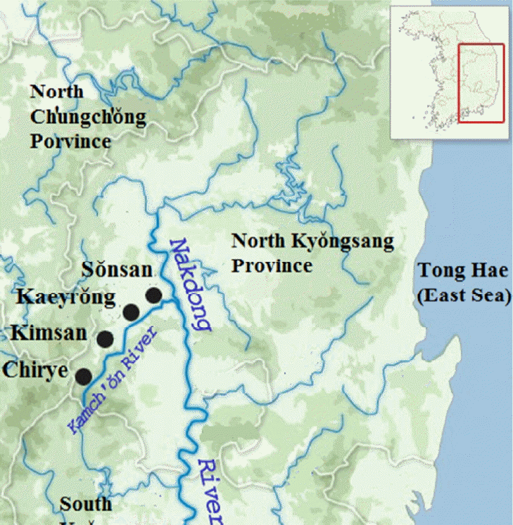
Overview of the Four Counties and Prefectures in the Sǒnsan and Kimch’ǒn Regions
This paper focuses on present-day Kumi and Kimch’ǒn, two cities located at the Kamch’ǒn (Gamcheon) River Basin, a tributary of the Nakdong River, in northwest Kyǒngsang Province, to trace the trend of the development of rice farming and of the local communities. According to the measure to reorganize the regional administration in 1994, all of Sǒnsan- bu (Seonsan County ) and part of Indong-hyǒn (Indong Prefecture) during the Chosǒn Dynasty were integrated into Kumi,7 and Kimsan-gun (Gimsan County), Kaeryǒng-hyǒn (Gaeryeong Prefecture), and Chiryehyǒn (Jirye Prefecture) were integrated into Kimch’ǒn. The two cities of Kumi and Kimch’ǒn are adjacent to one another, and they were similar in that they are both located along the 69km-long Kamch’ǒn River Basin that originates from the Sobaek Mountains in the Southwest and flows northeast into the Nakdong River. Figure 1 shows the locations of the four counties and prefectures in the Sǒnsan and Kimch’ǒn area during the Chosǒn Dynasty.
Although the regions were connected by the Kamch’ǒn River, they did not have the same natural geographic environment. While Sǒnsan (northeast)— located at a point where the Kamch’ǒn River met the Nakdong River—was a typical plain with developed lowlands, Chirye (south-west)—located at the foot of the Sobaek Mountains—was a typical mountainous area where small areas of plains existed in between rugged mountains. Kimsan, which was adjacent to the Sobaek Mountains in the north, boasted of broad plains to the south while the mountainous area to the north was well developed; Kaeryǒng, located between Kimsan and Sǒnsan, also extended on a typical plain, which was formed in a broad area with sediment buildup created from the flow of the Kamch’ǒn River. According to an expression from the Chosǒn Dynasty, Sǒnsan and Kaeyrǒng were yaǔp (野邑) (field county); Chirye was a sanǔp (山邑) (mountain county); Kimsan, a combination of the two.8 As a result, geographical conditions of the counties and prefectures will be noted in this paper as “yaǔp,” “sanǔp,” and “yaǔp and sanǔp combination,” unless they require a particular attention.
Among these four regions, Sǒnsan-bu, a yaǔp, was the largest (572.3km2) during the Chosǒn Dynasty, followed by Kimsan-gun (449.2km2), a yaǔp and sanǔp combination, Chirye-hyǒn (271.5km2), a sanǔp, and Kaeryǒng-hyǒn (244.5km2), a yaǔp. Chirye was slightly larger than Kaeryǒng in terms of surface area, but most of it was mountainous. As a result, Kaeryǒng was much larger than Chirye in terms of the prefecture’s real residential surface area.
Socio-economic Conditions in 1432
Various information from the Kyǒngsang-do Chiriji (Geographical Record of Kyǒngsang Province), created in 1432 (14th year of King Sejong’s reign), 40 years after the founding of Chosǒn Dynasty, reveals the socioeconomic conditions of the four counties and prefectures in the Sǒnsan and Kimch’ǒn area. Information included in Kyǒngsang-do Chiriji was later recorded in the Sejong sillok Chiriji (1454, the second year of King Danjong’s reign). All kinds of socio-economic information about the four counties and prefectures that appear in the Sejong sillok Chiriji have been organized into Chart 1.
According to <Chart 1>, Sǒnsan stood out among all three regions in terms of the number of households (1,005), men (5,607), soldiers (515), and the area of cultivated land (9,170 kyǒl). Among the indices listed above, the number of soldiers best shows the economic condition of the counties and prefectures, as it was based on the number of households and the area of cultivated land, which were two important socio-economic factors. The ratio of area to population density is broadly used as the best index of the degree of agro-economic development.10 In this context, the number of soldiers per 1km2 can reveal information about population density and agricultural productivity per unit of area. The number of soldiers per 1km2 was 0.90 in Sǒnsan at the time, which was significantly higher than Kimsan (0.62) and Chirye (0.48), with the exception of Kaeryǒng (0.92). This shows that the socio-economic conditions of Kaeyrǒng and Sǒnsan were the best, followed by Kimsan and Chirye in the early fifteenth century.
Geographically, Kaeyrǒng and Sǒnsan, the two regions with the best socio-economic conditions, were yaǔp. Kimsan, which followed the two regions was a yaǔp and sanǔp combination, and Chirye, the last of the four, was a sanǔp. This seems to show that regions that were closer to yaǔp had higher population density and better socio-economic conditions, while regions closer to sanǔp had lower population density and were less developed. Sǒnsan in the early and mid-fifteenth century supports this hypothesis. At the time, Sǒnsan-bu was a leading region in not only Kyǒngsang Province but across the Korean Peninsula in terms of socioeconomic, cultural, and ideological conditions.11
Sǒnsan was famous as a place where Kil Chae (1353–1419), a prominent Neo-Confucian scholar during the Chosǒn Dynasty, established the Yaǔn School, the first school of thought in Neo-Confucianism, for the pursuit of study. Many intellectuals gathered at Sǒnsan to learn from Kil Chae, and countless among them passed the literary civil service examination (mun’gwa) and filled government posts. A total of 36 intellectuals from Sǒnsan passed the literary examination within about 60 years since the founding of Chosǒn. Among them, five (Kim Hyojǒng, Pak Sǒsaeng, Kim Mal, Ha Wiji, and Kim Chigyǒng) served as scholars at Chiphyǒnjǒn (The Hall of Worthies), and ten (Kim Chayǒn, Kim Hyojǒng, Chǒng Ch’o, Pak Sǒsaeng, Kim Mal, Yi Sukjǒn, Ha Wiji, Yi Kyejǒn, Kim Kam, and Kim Chigyǒng) became high-ranking government officials of second rank or above. In particular, six scholars, including Chǒn Kasik, Ha Tam and Ha Wiji, who were father and son, Yu Myǒn, Chǒng Ch’o, and Chǒng Chidam, from the town of Yǒngbong in Sǒnsan, won the first or second places in the literary examination consecutively, thus earning the town the nickname changwǒnbang, or first-place town.12
Also, it is particularly important to note that major policy makers who proposed and pursued agricultural development policies during the era of King Sejong (1418–1450) were from Sǒnsan. Chǒng Ch’o, a government official from this region, was in charge of compiling Nongsa chiksǒl (農事直說) (Straight Talk on Farming) in 1429 (11th year of King Sejong’s reign); Pak Sǒsaeng led the construction of waterwheels in 1430; Ha Wiji was the author of Kwǒnnong kyosǒ (勸農敎書) (The farming promotion decree) in 1444 (26th year of King Sejong’s reign). Nongsa chiksǒl, complied by Chǒng Ch’o was in fact a book on farming that included agricultural technologies that have been collected from Kyǒngsang Province, which was a leading agricultural region at the time. It seems probable that agricultural technologies from the leading agricultural regions including Sǒnsan were written in the book.13
Chart 1 shows such socio-economic superiority of Sǒnsan. In 1432, the surface area of cultivated lands in Sǒnsan was 9,170 kyǒl. Paddy fields accounted for 5,500 kyǒl, which was slightly less than 2/3 (60%) of all the cultivated lands. At the time, there were only five regions where paddy fields accounted for 60 percent of all cultivated lands in 66 counties and prefectures in Kyǒngsang Province, including Sǒnsan, Dongnae, Hadong, Tansǒng, and Ǔiryǒng. Reflecting such superiority, Sǒnsan produced 0.9 soldiers per 1km2. Among the three counties and prefectures in the Kimch’ǒn area, the only place that surpassed Sǒnsan in terms of the number of soldiers per 1km2 was Kaeryǒng (0.92). Kimsan and Chirye merely produced 0.62 and 0.48 soldiers per 1km2 respectively. This meant that Kaeryǒng produced 102.2 percent of soldiers compared to Sǒnsan; Kimsan, 68.9 percent, and Chirye, 53.3 percent. The fact that Sǒnsan had such high socio-economic status can also be witnessed from the fact that the ratio of paddy fields to cultivated lands was high. The total area of paddy fields in Sǒnsan (5,502 kyǒl) was 1,592 kyǒl larger than the combined area of paddy fields in three other counties and prefectures in the Kimch’ǒn area (3,910 kyǒl). Since rice farming was the measure of leading agro-economic regions, Sǒnsan was highly superior to many other regions in Korea.
Then why was the economy dynamic in yaǔp, yet stagnant in sanǔp? The answer to this question is closely related to the fact that regional development was focused on plains and hilly areas. Most towns were located in the plains and hilly areas adjacent to streams or rivers.14 As a result, development became most active in the plains and hilly areas in the fifteenth century, when agricultural development policies were promoted. These were the areas where local elites resided. As for Sǒnsan, scholars and government officials were mainly produced from several villages and towns including Yǒngbong, located in the center of the provincial city. Chǒng Ch’o, the compiler of Nongsa chiksǒl, and Ha Wiji, the author of Kwǒnnong kyosǒ were from Yǒngbong village. Pak Sǒsaeng, the official in charge of producing waterwheels, was from Doryang village, Sanggumi-myǒn in Sǒnsan. The technocrats from Sǒnsan, who led the agricultural development policies in effect during the era of King Sejong, showed a lot of interest in regional development, centered on the plains and hilly areas.
In the plains and hilly areas, the best fields for rice farming were farmlands adjacent to reservoirs, which can supply water necessary for paddy fields. However, since reservoir construction was not active at the time, the area of farmlands with good water supply was limited. In these circumstances, the government devised a measure for paddy fields to sow rice seeds as early as possible, as irrigation conditions permitted. “Sugyǒng chikp’abǒp (水耕直播法)”, the farming method of broadcast seeding to wet rice fields, recommended for early-ripening rice plants in Nongsa chiksǒl, was the name of the technology.
Sugyǒng chikp’abǒp began to spread to other regions in the mid fifteenth century, as irrigation conditions were significantly improved with the construction of big and small reservoirs across the Korean peninsula during the era of King Sejo (1455–1468).15 At the time, regional development was centered around the plains and hilly areas, where reservoirs were mostly constructed, since reservoirs were mid- to large-scale water control facilities built in the plains and hilly areas.16 Therefore Kyǒngsang- do Chiriji in 1432 was a statistical survey that reflected the situation in the early fifteenth century, when regional developments began to occur, the population began to increase, and the economy began to develop, centered around the plains and hilly areas. As a result, while Kaeryǒng and Sǒnsan, which were yaǔp with developed plains and hilly areas, were economically sufficient, Kimsan and Chirye, which were a yaǔp and sanǔp combination and a sanǔp, lagged behind the former in terms of their economic status.
Regional Development in 1925
A statistical survey that shows a contrast with the socio-economic conditions in the early fifteenth century is the Report on the Chosen National Census (Chosǒn kukse chosa bogo) written by the Government-General of Chosǒn (Chosǒn ch’ongdokbu) in 1925. This report is the first modern census conducted in Korea and includes information about the population, the number of households, men, women, and members of households, etc. Since a series of colonization policies that the Government-General of Chosǒn implemented would not have taken as much effect in 1925, census reports from this period would contain relatively well-preserved trends of premodern Korea. Therefore this paper sees this report as a document that reflects the socio-economic achievements that the Chosǒn society had accomplished in the late nineteenth and early twentieth centuries.
In a pre-modern society, the population reflects the degree of socioeconomic development of a region. Population density per unit of surface area is an important index that shows the region’s capacity to support the population.17 An area with high population density can be considered as a place that has the capacity to handle the population pressure, a common challenge faced by humanity. On the other hand, an area with low population density can be interpreted as a place that has either failed in overcoming the challenge or an untapped territory that still has the possibility to support the population. Chart 2 shows the number of households and the population of the four counties and prefectures in the Sǒnsan and Kimch’ǒn areas in 1925.
In a modern society, an individual, rather than a family or a community, is a more important unit of economic activity. This is the most different aspect of modern society, compared to premodern society, which families and communities are the centers of economic activities. Therefore this paper will focus on the individual population density per unit of area for each place.
Chart 2 reveals a remarkable fact in terms of population density per unit of area. Compared to Sǒnsan, Kimsan (118.4) had the highest population density, followed by Kaeryǒng (115.1), and Chirye (100.01). Population in Sǒnsan was the lowest.
It is not a surprise that Kaeryǒng, which surpassed Sǒnsan in terms of economic capacity in the early fifteenth century, had a higher population density than Sǒnsan. However, the growth of Kimsan and Chirye was remarkable. Kimsan, whose economic capacity was only 68.9 percent of that of Sǒnsan up until the early fifteenth century, boasted the highest economic capacity to support the population (68.9→118.4), and Chirye, whose economic capacity was only about half of that of Sǒnsan, also surpassed Sǒnsan (53.3→100.01). The high population density in Kimsan is deeply related to the fact that Kimch’ǒn, which incorporated Kimsan, became the most important center of transportation in the northwest area of North Kyǒngsang Province since the construction of the Kyǒngbu Line Railway (Kyǒngbusǒn) in 1904. Kimch’ǒn-myǒn (Township of Kimch’ǒn) was divided into seven districts such as honmachi (本町) and asahimachi (旭町), and a total of 13,049 people and 2,903 households inhabited the town.
The most significant accomplishment, however, was achieved by sanǔp Chirye, located in an isolated area, deep in the mountains, far from the modern ideal of a city. Therefore it would not be an exaggeration to say that Chirye holds the key to understanding the trend of socio-economic development in the Chosǒn Dynasty over 500 years from the early fifteenth to early twentieth centuries. Hidden behind Chirye’s remarkable achievement was a shocking downturn of Sǒnsan. This paper will further examine this phenomenon of sanǔp’s success over yaǔp during this time and explore universal aspects of Chirye’s success over Sǒnsan. A related statistical survey is the Report on Arable Land and Production in Korea (Han’guk t’oji nongsan chosa pogo), which is a description of the agroeconomic situation in each county and prefecture in Kyǒngsang Province collected by the Residency General of Korea in 1905. At the time, Japanese surveyors collected information regarding the total area of farmlands in Kyǒngsangbuk-do and Kyǒngsangnam-do (South Kyǒngsang Province), as well as the ratio of paddy fields and dry fields, as noted in Chart 3.
According to Chart 3, paddy fields accounted for 71.5 percent (329,767.4 chǒngbo) of total farmlands in Kyǒngsang Province, surpassing the area of dry fields, which accounted for 28.5 percent (131,233.1 chǒngbo). The total surface area of paddy fields in North Kyǒngsang Province (76.7%) was larger than that of South Kyǒngsang Province (65.1%), which shows that rice farming was more actively promoted in North Kyǒngsang Province than South Kyǒngsang Province. This survey is quite intriguing as it goes against the general expectation that rice farming would be more developed in the South Kyǒngsang Province region, known for its mild weather and plains and hilly areas, and dry field farming would be more prevalent in North Kyǒngsang Province.
In order to understand this phenomenon more accurately, it is necessary to examine the geographical conditions as well as the share of paddy fields and dry fields of each county and prefecture more in detail. Japanese surveyors at the time organized the surface areas and the distribution ratio of paddy fields and dry fields for all 16 counties and prefectures in South Kyǒngsang Province and North Kyǒngsang Province, particularly by geographical features. Based on this, all 16 counties and prefectures were divided into yaǔp, sanǔp, and yaǔp and sanǔp combination, to compare the ratio of paddy fields and dry fields in Chart 4.
According to <Chart 4>, yaǔp counties and prefectures with the least amount of paddy fields were Yǒngsan (25.2%), Samnangjin (Yangsan; 33.3%), Ch’ogye (54.3%), Konyang (57.0%), and Haman (59.8%). Yaǔp counties and prefectures with the most amount of paddy fields were Sach’ǒn (92.8%), Indong (80.4%), Tadaep’o (Pusan; 76.8%), Sǒnsan (72.6%), Ch’angwǒn (69.7%), and Kimhae (60.7%). In most yaǔp counties and prefectures (5 out of 8), paddy fields accounted for generally 50 to 60 percent of farmlands. On the other hand, paddy fields were evenly distributed throughout yaǔp and sanǔp combination, with the least amount in Miryang (40.5%) and the most in Sǒngju (77.0%). The ratio of paddy fields to all farmlands was higher in counties and prefectures with yaǔp and sanǔp combination, compared to yaǔp. In Ǔisǒng, which is a sanǔp, paddy fields accounted for 90.3 percent of all farmlands, significantly higher than the amount of dry fields, which only accounted for 9.7 percent.
Chart 4 is not a complete survey as it only takes into account 16 counties, instead of all 71 counties in Kyǒngsang Province. However, it is clear that paddy fields were more developed in the mountainous regions in North Kyǒngsang Province (Ǔisǒng), while dry fields were more developed in the plains and hilly areas in South Kyǒngsang Province (Yǒngsan and Samnangjin). This shows us that rice farming was relatively more developed in sanǔp and dry field farming was relatively more developed in yaǔp in the late nineteenth and early twentieth centuries. This geographical condition is closely related to the fact that there were more paddy fields in North Kyǒngsang Province than in South Kyǒngsang Province. In other words, the most important factor in rice farming in traditional Korea was not climate but rather geographical features.20
Taking into account the agricultural structure in Korea in the late nineteenth and early twentieth centuries, let us examine once again the degree of socio-economic development in the four counties and prefectures in the Sǒnsan and Kimch’ǒn area in 1925. Among the four regions, the economy of Kimsan, a yaǔp and sanǔp combination, was the most developed, followed by Kaeryǒng, a yaǔp, and Chirye, a sanǔp. Sǒnsan, a typical yaǔp, was the least developed. All three counties and prefectures in the Kimch’ǒn area surpassed Sǒnsan in terms of socio-economic development. This was a remarkable statistical record, as it points to the economic decline Sǒnsan experienced, stripped of its former glory as the most advanced agricultural region in Kyǒngsang Province as well as in Korea throughout the fifteenth century.20
However, when we consider the agricultural structure by region, organized in Chart 4, the decline of Sǒnsan is not surprising. The main cause of the socio-economic differences between the four regions was the agricultural structure by geography, where sanǔp were paddy field areas and yaǔp were dry field areas. Over 500 years since the early fifteenth century to the early twentieth century, the economy of Chirye grew the fastest (53.3→100.01). This growth is closely related to the geographical feature of Chirye, which was deep in the heart of the mountains, because mountainous regions were favorable for rice farming.
Climate in Kyǒngsang Province and the Development of Agricultural Methods in the Yǒngnam Area
Climate in Kyǒngsang Province
How, then, was rice farming able to develop in the mountainous regions in premodern Korean society? In order to answer this question, it is important to take a look at the climatic conditions in Korea, since agriculture is an economic activity that is closely related to the climatic and geographic conditions. The most important elements in agriculture were natural conditions, such as average temperature, the amount of rainfall, and the amount of sunlight. Since the seventeenth century, rice farming was the most developed in China, Japan, and Korea in East Asia. Among them, Jiangnan in China, Kansai in Japan, and Kyǒngsang Province in Korea were the most advanced. These regions were East Asian monsoon areas, with high temperature and humidity and sufficient amount of rainfall during the summer (June through August) when rice plants grow.
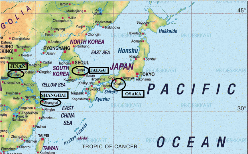
However, these three regions were marked by differences, as much as they had commonalities. In order to find out these differences, this paper will now compare the climate of Jinan (36° 40′N) in Huabei and Shanghai (31° 12′N) in Jiangnan, China, Osaka (34° 41′ 38″N) in Kansai, Japan, and Taegu (35° 52′N) in Kyǒngsang Province, Korea. Figure 2 is a map of the aforementioned four regions in East Asia.
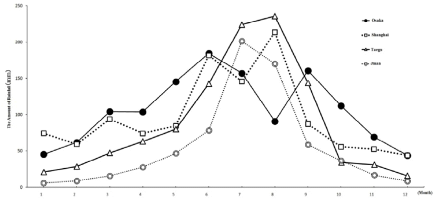
Figure 3 and Figure 4 are graphs of the average high and low temperatures, and the amount of rainfall of these four regions by season.
The average low temperature for crop growth was 5°C, since all plants stop growing when the temperature falls below 4°C and frost forms on the ground. In Shanghai, China and Osaka, Japan, crops begin to grow after March; in Jinan, China and Taegu, Korea, after April. The farming season lasted until late fall, when frost formed, which was October for Taegu and Jinan, November for Shanghai, and December for Osaka. In that aspect, the farming season was the longest in Osaka (10 months), followed by Shanghai (9 months), and Jinan and Taegu (7 months). Due to these climatic conditions, double cropping of rice in the paddy fields was possible in Osaka and Shanghai, yet Jinan and Taegu had barely enough time for single cropping. The amount of rainfall in the spring (March through May), the early growth period, and in the summer (June through August), the full growth period, was very important. Osaka had the most favorable climatic conditions for rice farming. The average temperature in March was 5.6°C in Osaka, and over the three spring months (March through May), the amount of rainfall was 27.7 percent (353.8mm). Moreover, the amount of rainfall recorded 11.8 percent (150.9mm) even in the winter, provided sufficient water for farming in the spring. Shanghai had the next favorable conditions for rice farming. The average temperature was already 6.9°C in March, and the amount of rainfall was evenly distributed in the winter (16.7%; 195mm) and spring (21.7%; 252.5mm), and so it was not difficult to sow or plant rice. In this aspect, Osaka and Shanghai had the best conditions for rice farming.
Compared to these two regions, the climatic conditions in Taegu were unfavorable for rice farming. Only in April when the average temperature reached 8.4°C, it was possible to start farming in Taegu. However, the amount of rainfall was only 17.9 percent (190mm) for the three months in the spring, and 6.0 percent (64.1mm) over the three months in the winter. Rice was planted in Taegu after April, and farmers had to overcome a long period of dry season for about six to seven months from the winter to late spring.
The climatic conditions were worse in Jinan. It was only possible to plant rice in April in Jinan, only when the average low temperature reached 11.3°C. In addition, the average annual rainfall was only 672.8mm, significantly lower than Osaka (1279.0mm), Shanghai (1161.1mm), and Taegu (1064.4mm). A total of 66.9 percent (449.9mm) of rainfall occurred in the summer, but most of the precipitation began in July (201.3mm). This meant that the dry season that began in October lasted until June, over nine months in Jinan. Due to this long dry season, rice farming was extremely difficult. Therefore, in Jinan, it was more advantageous to farm wheat, which does not require heavy rainfall.21
However, it was not impossible to plant rice in Jinan. It was possible to plant rice in the fields with the right irrigation conditions to overcome the long dry season that lasted until June. Paddy fields with naturally favorable irrigation conditions were such fields. However, even then, early cultivation was the most important factor in order to overcome the long dry season in the spring, and this rice farming technology was also emphasized in the Nongshangjiyao (農桑輯要) (Fundamentals of Agricultural and Secriculture), compiled by the Board of Agriculture (Sinongsi) in 1272 during the Yuan Dynasty, as well as in Nongshu (農書) (Book of Agriculture) published by Wang Zhen from Dongping County, Shandong, in 1313.
Agricultural Methods in the Yǒngnam Area and Korean-pattern Regional Development
In terms of latitude, average temperatures, and rainfall by season, Taegu was more similar to Jinan than Osaka or Shanghai. As such, Korean rice farming was most influenced by the agricultural practices in Huabei, China. The preference for early-ripening rice plants during the process of sugyǒng chikp’abǒp in the fifteenth century, early yiangbǒp (移秧法) (the method of transplanting rice seedlings) since the seventeenth century, and the focus on early-ripening, cold-resistant, and water-endurable rice plants in the process of differentiating the variety of rice plants after the eighteenth century were all related to the influence the agricultural methods of China’s Huabei had on Korean farming technologies.22 This was also the reason Wang Zhen’s Nongshu, a major book of agriculture in the Huabei region, was broadly used in Korea up until the sixteenth century.23
However, the major difference between Taegu and Jinan was the water supply. Taegu received more rainfall (1064.4mm compared to Jinan’s 672.8mm), and secured relatively more water for agriculture due to the rainy season starting in June (142.6mm compared to Jinan’s 78.3mm). Taegu was somewhere in between Jinan, which was a dry field region, and Shanghai and Osaka, which were paddy field regions. Due to these climatic factors, agricultural water had to be procured as much as possible for rice farming in Taegu. As a result, irrigation facilities were the most important for rice farming in Taegu. In this aspect, rice farming in Taegu was different from that of the Jiangnan region in China or the Kansai region in Japan, and also from that of Huabei in China. Therefore the rice farming technologies that were used in Kyǒngsang Province can be called, “agricultural methods in the Yǒngnam area.”24
In the early fifteenth century, when rice farming was first introduced, the Korean policy makers in charge of pursuing agricultural development policies knew the urgency of dramatic improvement in irrigation conditions. This was the reason why King Taejong (1400–1418) constructed reservoirs across the Korean peninsula, and the Chosǒn government from the reign of King Sejong to the reign of Sǒngjong (1469–1494), put their utmost efforts in securing irrigation facilities in various ways. However, most of the government-led irrigation engineering projects (reservoirs, waterwheels, and diversion weirs) in the fifteenth century ended as failures, mainly because regional developments until the fifteenth century centered on the plains and hilly areas. Reservoirs, the major irrigation facilities constructed in these areas, were ineffective in terms of water control despite the size of the labor force and funding put into the projects. The reservoirs were barely useful in providing agricultural water to the farmlands located right below the reservoirs.
With most of the government-led irrigation engineering projects that were carried out until the late fifteenth century ending up as failures, a breakthrough came from a completely unexpected place: diversion weirs that were privately built in the mountainous regions. In the valleys of the mountainous regions, there were a number of streams that flowed down from the high mountains. Although the amount of water in these streams did not add up to much, these streams did not dry out at any part of the year. Farmers were able to secure a certain amount of agricultural water relatively easily by blocking these streams with rocks or trees. Since these were small streams, the labor force and capital invested in the construction of diversion weirs were not significant. Each diversion weir could be maintained and managed by about four to five households each.25 In addition, it was possible to build diversion weirs at various levels, since weirs constructed in the valleys allowed for a downward flow of water due to the differences in elevation. Agricultural water that was procured through these diversion weirs was supplied to terraced rice paddies, which then flowed into the paddies on the bottom.26
As irrigation conditions were greatly improved through the use of small-scale diversion weirs, it was possible to carry out rice farming in the mountainous regions, even with the relatively small amount of rainfall of about 60mm after April, when full-fledged farming began. Around this time, Korean farmers focused on yiangbǒp, or method of transplanting rice seedlings. One another condition that decided the success or the failure of rice farming was weeding. Generally, in rice farming, which lasted from spring to fall, the paddies needed to be weeded as much as seven times. However, if rice plants are transplanted, the paddies only needed to be weeded three or four times, dramatically reducing the necessary labor. Compared to sugyǒng chikp’abǒp, yiangbǒp reduced labor by over 70 percent, which were then put to use in farming summer plants, such as cotton or tobacco.27 Since it allowed farmers to farm rice and other plants in the fields during the summer, yiangbǒp attracted attention as a popular rice farming technologies in the mid to late seventeenth centuries when a huge population had to be supported due to an increase in population.
Yiangbǒp began to spread in the early to mid-sixteenth century, when the development of the mountainous regions began in full force, because diversion weirs, which were generally built in the mountains, were necessary to practice yiangbǒp. Among the three East Asian countries, premodern Korea was particularly unique, as rice farming and regional development were centered around the mountainous regions. In the Chinese Jiangnan area, rice farming and regional development were centered around the low-lying fields along the river.28 Korea’s unique type of regional development was closely related to the climatic conditions in Korea. In this aspect, the regional development that was carried out in Korea since the sixteenth century, when development was centered around mountainous regions where the construction of diversion weirs were advantageous, can be called “Korean-pattern regional development.”29
The period of development for the mountainous regions varied depending on the level of population pressure. Population pressure was the highest in central and northern Kyǒngsang Province, the leading agricultural region since the fourteenth century. In these regions, the development of the mountainous areas began in the early sixteenth century, and as a result, some of the farms were experimenting with yiangbǒp. The next regions with high population pressure were southern Kyǒngsang Province and part of Chǒlla Province (Jeolla Province). In these regions, yiangbǒp began to be practiced after the mid- to late sixteenth century. However, population pressure in general was relatively low throughout the sixteenth century, and therefore yiangbǒp began to be spread in the rest of the regions only in the early to mid-seventeenth century, when the population began to increase again.
Going back to the economic conditions in the northwestern part of North Kyǒngsang Province in the 1925, Sǒnsan had the least ability to support its population, followed by Chirye. Kimsan and Kaeryǒng enjoyed the best economic conditions among the four areas. The weakness of Sǒnsan was closely related to the geographical condition that it was a yaǔp with relatively more developed dry fields than paddy fields. The fact that Chirye, which was only half as big in terms of the economy in the early fifteenth century, was able to grow and match the level of Sǒnsan is also related to the fact that it was a typical sanǔp, suitable for rice farming. In this context, the Report on the Chosen National Census is a document that clearly shows where the destination of Korean-pattern regional development and the agricultural methods of the Yǒngnam area were in the late nineteenth and early twentieth centuries.
The Change in the Residential Areas and Economic Views of the Local Elites
The Change in the Residential Areas of the Local Elites by Time Period
Residence in Towns: Fifteenth to Sixteenth Centuries
Throughout the fifteenth century, regional development was centered on the plains and hilly areas, where towns were located. During this time, reservoirs were constructed extensively around towns and the surrounding areas, led by the government under its rigorous initiative to improve agricultural productivity. In farms that were irrigated through the construction of reservoirs, farmers experimented with sugyǒng chikp’abǒp, a new agricultural technology at the time. The regional development around this time was collaboration between the government, which pursued agricultural development policies, and local elites. Residing in towns and nearby villages, local elites actively took part in the government’s policies. Therefore this was a period when developments took place in the plains and hilly areas, which became socio-economically vibrant as a center of culture and ideology. As a result, local elites lived in towns or in the surrounding areas until the late fifteenth century.
In the late fifteenth century, regional development in the advanced agricultural lands, centered around the plains and hilly areas, such as Sǒnsan, begin to dwindle with increased population pressure. With the existing agricultural technologies, it was difficult to support the increasing population. Local elites needed to establish a new base to support the increased population while maintaining their quality of life. The new lands these local elites pioneered were the low-level mountains relatively close to the towns.
As the migration to the mountains began, local elites had to devise an agricultural technology that was suitable for farming in the new environment. So they came up with yiangbǒp. Yiangbǒp was possible to be adopted in the mountainous areas because it was easy to construct diversion weirs, which were irrigation facilities that irrigated the paddies by temporarily blocking the streams that flowed through the mountain valleys. It was possible to construct the weirs with very little small capital and a small labor force, and it was also easier to provide agricultural water to the paddies, utilizing the differences in elevation in the mountainous areas.
However, up until the early to mid-sixteenth century, the development of the mountainous regions had not begun in full force. As a result, local elites maintained their residence in the towns while setting up their new residence in the mountain villages. However, as time passed, local elites gradually and completely moved from towns to mountain villages. Overcoming the challenge of population pressure by moving to the mountains and adopting yiangbǒp, these local elites were able to become sajok, or yangban, the real ruling class of the Chosǒn society around this time.30
Yiangbǒp was developed in the central and northern North Kyǒngsang Province areas, the leading agricultural region since the early sixteenth century and a highly populated area. After the mid- to late sixteenth century, yiangbǒp spread to southern Kyǒngsang Province and parts of Chǒlla Province.31 However, Chosǒn’s economy, which had grown under the strict control and intervention of the government, was on a decline in the sixteenth century. As a result, population growth also stalled, if not decreased. The population of Chosǒn Korea was fixed at around 10 million until the late sixteenth century.32
Agricultural Villages in the Mountains: Seventeenth to Nineteenth Centuries
For about 70 years since the end of the Japanese Invasion of Korea (1592–1598) in 1598, changes began to occur with the stabilization of Korean society and the development of the economy. The population of Korea grew steadily. In the 1670s, the population of Korea increased to 11 million, nearly doubling since the period immediately after the war.33 With the population rapidly increasing, Chosǒn society suffered from the problems of population pressure. Around this time, Chosǒn society emphasized the development of the mountainous areas and the spread of yiangbǒp to resolve this problem. Yiangbǒp, which had been contained in Kyǒngsang Province and part of Chǒlla Province began to spread across Chosǒn in the early to mid-seventeenth century. Ch’ungch’ǒng-do (Chungcheong Province) adopted yiangbǒp in the first half of the seventeenth century; Kyǒnggi-do (Gyeonggi Province), in the mid- to late seventeenth century. Therefore in the first half of the eighteenth century, all six provinces, with the exception of Kangwǒn-do (Gangwon Province) and Hamkyǒng-do (Hamgyeong Province), adopted yiangbǒp.34
Yiangbǒp was a type of agricultural technology for rice farming, using diversion weirs to irrigate the fields. Therefore the process of spreading yiangbǒp toward the north, to Hwanghae-do (Hwanghae Province) and P’yǒngan-do (Pyeongan Province) was a process of developing the mountainous regions, where diversion weirs were constructed. As the mountainous regions began to attract attention as an advantageous area for yiangbǒp, more and more sajok began to move to the mountain villages. Therefore after the late-seventeenth and early eighteenth centuries, sajok no longer resided in the towns.35 This movement of sajok from the towns to the mountains was called “t’oech’on (退村),” or literally, moving out of town.36
The efforts to resolve the problems of population pressure through the development of the mountainous regions and spread of yiangbǒp were expected to meet their limitations, as the population continued to increase during the so-called “Peace of the Eighteenth Century” during the reigns of King Yǒngjo and Chǒngjo (1724–1800). In order for Chosǒn society to free itself from the Malthusian trap, an excessive labor force needed to be released to the outside world, or a new and innovative technology needed to be adopted to increase social productivity, just as western European countries had done. However, Chosǒn society was mostly unaware of these historical trends throughout the world. As a result, Chosǒn society was gradually pulled into the Malthusian trap after the mid- to late eighteenth century.
In these circumstances, the only choice left for Chosǒn society was to expand paddy fields as much as possible. For southern Korea, rice farming was possible up to a 750m altitude, and yiangbǒp was possible at around a 500m altitude. This meant that yiangbǒp and “extensive” rice farming was possible in the mountainous regions, located in between 500m and 700m altitude.37 As a result, development reached the mountainous regions above 500m altitude, and people rushed to these areas. Therefore a huge population began to reside in the mountainous regions since the late eighteenth century.
As a huge population began to reside in the mountains, the natural environment began to be destroyed. To create farmland, nature had to be destroyed, and trees had to be cut as fuel supply. To keep the farmland fertile, leaves and grass had to be deposited on the fields. In this process, lush forests were turned into bare mountains without trees or grass.38
As mountains all across Korea were turning into bare mountains, more problems occurred. Even with a small amount of rainfall, soil erosions as well as landslides took place in all corners of Korea, and valleys were filled with the soil from the landslides. The soil that flowed down into the low-lying fields along rivers and streams began to accumulate on the bottom of the rivers and streams, making these waterways flood, damaging the nearby farmlands. Peasants in the low-lying areas built higher dykes to prevent the damage from floods, but it was impossible to stop the accumulation of soil in the riverbeds. As this situation persisted, paddy fields located on the low-lying area along rivers and streams were turned into dry lands due to sediment buildup from landslides, and it was no longer arable.
As a result, peasants in the low-lying area along the rivers and streams had to give up on agriculture and move to different places. Their destination was villages at the foot of the mountains that led deep into the mountains or nearby sanǔp.39 While yaǔp located on the low-lying areas along the rivers and streams became more devastated, sanǔp in the mountains were becoming crowded with people. A contrasting socio-economic phenomenon continued in the late eighteenth and early nineteenth century, with the decline of yaǔp and growth of sanǔp. This was one of the reasons that made it possible for Chirye, a remote sanǔp located deep in the mountains, to surpass Sǒnsan, which was a typical yaǔp, in terms of its economic capacity in 1925.
As premodern Korean-pattern regional developments occurred in the mountainous areas, sajok preferred to reside in agricultural villages in the mountains. Yi Chunghwan (1690–1752), the author of T’aengniji, or Guide to selecting a village, declared, “Residing near the sea is not as good as residing near a river, and residing near a river is not as good as residing in a valley.”40 In other words, he claimed that it was better to live in the plains and hilly areas inland, rather than a fishing village by the sea, and all the more better to live in the valley in the mountains. Yi organized the preference of residence for sajok, who moved from the towns near rivers and surrounding areas to mountain valleys in the mid- to late eighteenth century, into a “concept of preference for residence in valleys.”
The Change in the Economic Views of the Local Elites
As Korean elites moved to the mountains starting in the eighteenth century, western European elites at the time were moving in the completely opposite direction. With the Age of Mercantilism that began in the seventeenth century, western European countries became interoceanic nations, and focused their national power on trade overseas. From small and narrow agricultural fields in the valleys, they crowded the river basins, where people and goods gather and disperse; as overseas trade and navigation became the most crucial means to accumulate wealth, western Europeans moved to ports and harbors along the coast. These cities were vitalized due to merchants who flocked to them, and commercial capital was accumulated and distributed from these cities.41 Such early capitalistic economic activities also affected agricultural villages and towns. As a result, agricultural villages began to supply commercial crops for the people residing in cities along the river basins or harbor cities along the coast. In the end, the history of capitalism in Western Europe was a process of capital that was created by marine cities moving to inland cities and to rural villages.
Around the same period, Korean history was heading in the completely opposite direction from the route of Western European history. Sajok only focused on holding a government post by studying Confucian ideologies and farming as a means of living. They did not even consider other economic activities such as trade, craft, or fishing, which might damage agricultural economy or threaten the social structure that was founded upon agriculture. As a result, fishing villages were generally abandoned, and towns, which were administrative centers along the rivers, lost their vitality. Only the farming villages located in the mountain valleys continued to maintain liveliness.
Since the eighteenth century, sajok were extremely reluctant to reside in the towns. They looked down upon and oppressed city residents, except the regional government officials dispatched by the central government, calling them “sangmin,” or commoners. A regional structure was established, with sajok, the local elites and residents of agricultural villages, ruling over the town residents. Sajok made a living by serving in the government or farming. If they became poor and had to making a living by trade or crafts, main sajok would sever ties with them and strip their rights to hold government posts, considering them to have been fallen as sangmin. As such, sajok gradually became “closed elites” from the eighteenth century.42
As more and more people began to reside in small agricultural villages in the mountains, Chosǒn society fell deeper into the trap of a closed agricultural society. The members of society saw the act of accumulating wealth as a means to destroy the community, and even when they did accumulate wealth, they spent it all away, flaunting their wealth. As a result, wealth was not accumulated, but rather, consumed. Therefore the wealthy and the poor, as well as the rulers and the subordinates all lived a poor life, accepting poverty as their fate.43
Under these circumstances, those who participated in productive activities as well as the wealthy were hated; laziness and indolence became values that were praised. “Hǔngbuga,” or the Song of Hǔngbu, which became popular in the late Chosǒn Dynasty, was a p’ansori that clearly reflected the general economic view of the ruling class. In this way, all became poor and interdependent as members of a closed agricultural society. Various aspects of the “trap of a closed agricultural society” worsened after the late eighteenth century because most Koreans lived in the mountainous regions, which became the center of economy and culture.
Conclusion
Various aspects of premodern Korean society that became distinct after the mid- to late eighteenth century were different not only from those of western Europe, but also from China and Japan during the same period. The Chinese gentry class and Japanese samurai generally resided in cities from the mid- to late seventeenth century. Such city residents interacted with merchants and crafts, and some of them even entered the trade and industrial fields. Ironically, merchants and crafts who interacted with the elites gradually became intellectuals themselves, and even held government posts. This was a trend that is particularly distinctive in the Jiangnan area in China. In this region, the boundaries of class and hierarchy between local elites and merchants gradually deteriorated in the mid- to late seventeenth century, and a new class called “shenshangceng” (紳商層), or gentry-merchants, was created. As more people from the “shenshangceng” passed the civil service examination, the Chinese intellectual tradition of considering government officials superior to others gradually tarnished.44
This is the point of distinct difference in the process of modernization in the three East Asian countries. Japanese samurai, who were only allowed to live in cities, relied heavily on merchants and crafts. As a result, they even looked for ways to make a living through trade and craftwork.45 The Chinese gentry from Jiangnan also shared wealth and knowledge with merchants through close interactions and indirectly, as well as directly, helped the merchants from prospering in society.
However, the Chosǒn sajok who resided in agricultural villages did not recognize any other economic activities besides farming. They looked down on town residents as commoners and did not form an economically dependent relationship with the merchants who lived in towns. Unlike in Jiangnan, China and Japan at the time, a closed regional structure in which agricultural villages ruled over cities was firmly instituted in Chosǒn. As long as the agricultural elites looked down on their subordinates living in towns and oppressed the merchants and crafts, it was difficult to lay the foundation for the development of trade and industry.
As such, when the harsh wave of modernization that began in Western Europe in the early to mid-nineteenth century rushed into East Asia, China, Japan, and Korea all responded in a different way. The Japanese samurai accumulated capital by devoting themselves to trade and industry, and participated in the Meiji government-led movement to transition into a modern nation. The Chinese elites in Jiangnan also encouraged the accumulation of wealth and even formed a new social class called “shenshangceng,” putting their utmost efforts into the modernization of the Chinese society. However, the Korean sajok did not budge, refusing to accept any of the government’s measures and policies for modernization, even until the Kabo Reforms in 1894, when the elites were permitted to take part in trade and industry. Asserting the concept of “wijǒng ch’ǒksa,” (衛正斥邪) or “defending orthodoxy and rejecting heterodoxy,” sajok insisted on a pure neo-Confucian world and wanted to maintain the status quo.
Kajimura Hideki explains the success and failure of modernization for the three East Asian nations in the period in which the three nations opened up to the Western powers and the degree of external pressure. Since its opening in 1854, Japan was given about 14 years of time for voluntary modernization until the Meiji Restoration in 1868, and as a result, modernization occurred smoothly. China had 19 years to modernize from the Treaty of Nanking in 1842 to the Yangwu Reforms in 1861, but it became a semi-colony, unable to withstand the pressure from Western imperialists, including Great Britain, France, and Germany. On the other hand, Korea opened up in 1876 and was the last to open up among the three nations. However, after the Kapsin Coup took place eight years later (in 1884), and later became a colony as the surrounding countries, Japan and China, which were in the stage of accumulating primary capital, intervened right away.46
This thesis is possible when we assume that the economic status and confrontational power of the three East Asian nations—Japan, China, and Korea—are the same. However, the economic status and social structure of the three nations were very different. Therefore it is questionable whether the three nations would have met the same end if the time of the opening and the time of reform were the same for all of them.
Behind the development of rice farming technologies and regional development, which created differences in the process of modernization in the three countries, were the differences in natural environment. Korea, which had the least suitable environment for rice farming, attempted to overcome this environmental obstacles by developing the mountainous regions and adopting yiangbǒp, which led to the development of the mountainous regions and movement of local elites to agricultural villages. Local elites in agricultural villages abhorred and oppressed trade and craft, which threatened agricultural communities, and as a result, it was barely possible for merchants to grow or for commercial capitalism to develop. This was the fundamental difference between Korea and Jiangnan, China or Japan.
Among the three East Asian countries, Korea had the least favorable agricultural environment and geographic conditions. As a result, Korea suffered the most in the process of modernization among the three nations. 47 That is the reason why Korea was a colony of Japanese imperialism for over 36 years (1910–1945). However, the unfavorable agricultural environment in Korea also made a significant contribution by introducing and popularizing rice farming in the barren lands of Manchuria, where Koreans moved to during the Japanese colonial period. This was also the reason for the historical and cultural obsession for rice farming, and the Korean people’s unrelenting tenacity to overcome the extreme natural and climatic conditions.